 |
||||||||||||||||||||||||||||
 |
||||||||||||||||||||||||||||
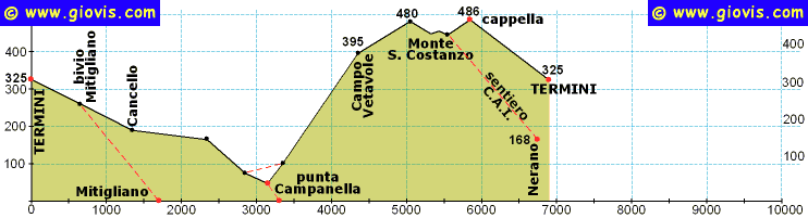
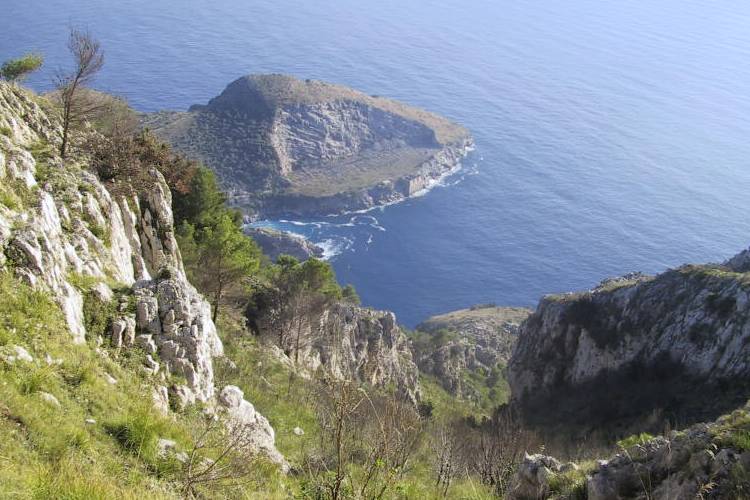
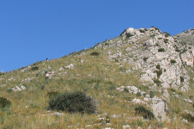
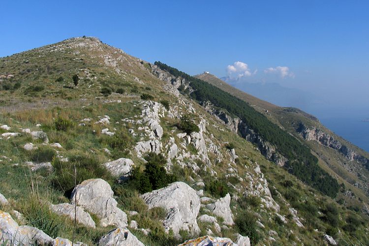
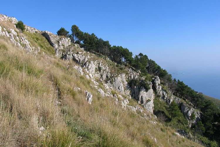
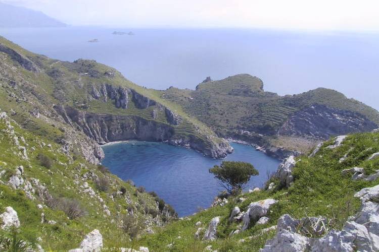
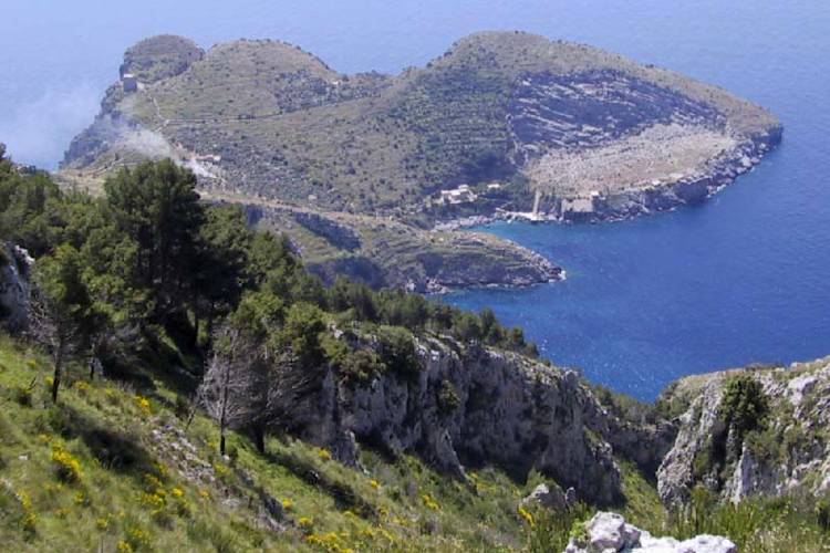
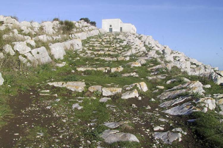
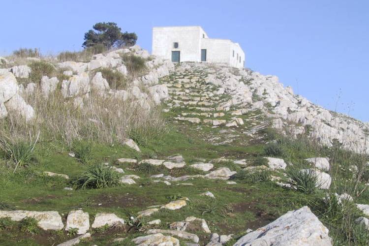
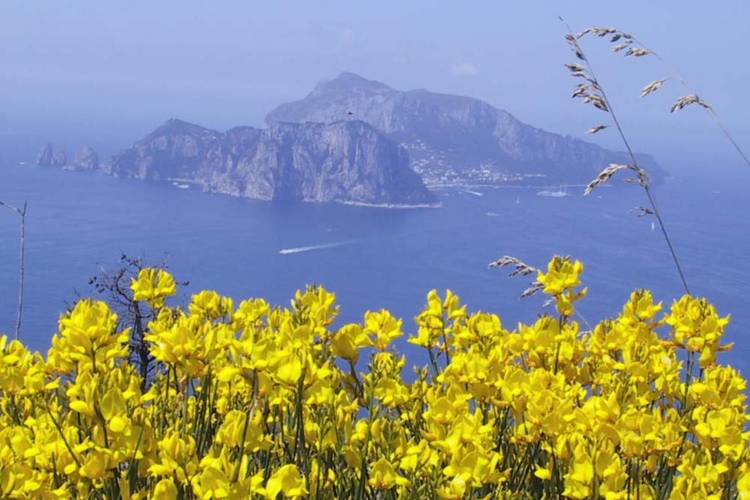
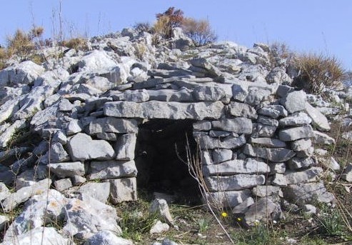
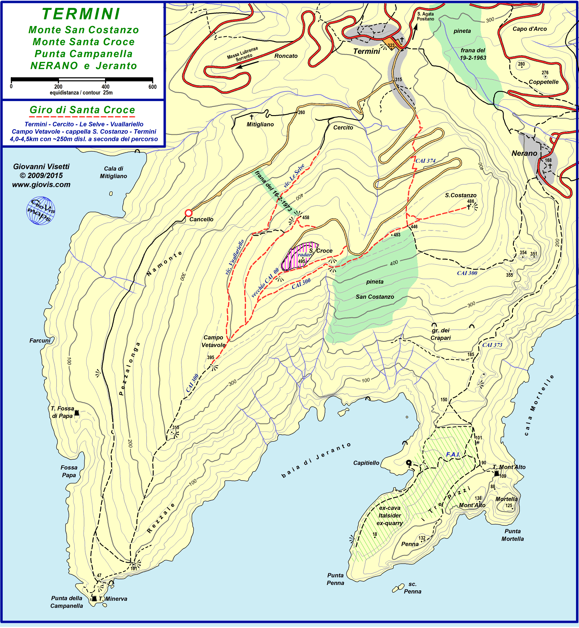
Termini è senz'altro il miglior punto di partenza per un'escursione a Monte San Costanzo e ci sono svariate possibilità di effettuare circuiti che ci riportino al punto di partenza percorrendo sentieri diversi. Il giro classico è in effetti un triangolo i cui vertici sono Termini, Monte San Costanzo e Punta della Campanella. In base alle condizioni meteo, alla temperatura ed ad altre considerazioni lo si affronterà in un senso o nell'altro; in entrambi i casi è una escursione spettacolare. Descriverò l'escursione nella direzione che preferisco, cioè in senso antiorario. Si lascia la piazza di Termini seguendo i segni gialli e dopo circa 200m si lascia la strada che continua diritta verso Monte San Costanzo e si comincia a scendere. Fino alla Punta non c'è praticamente possibilità di sbagliare strada: si segue la stradina principale (il cui stato peggiora man mano che ci si allontana da Termini) lasciando a sinistra via Cercito e poi a destra via Mitigliano. Dopo questo secondo incrocio si continua a scendere fino a Cancello (passaggio fra il costone ed un pinnacolo roccia). Prima di attraversare questo "ingresso", se effettuate l'escursione fra gennaio e marzo, vedrete in alto a sinistra i bellissimi fiori "blu elettrico" della Lithodora rosmarinifolia, pianta endemica della Penisola Sorrentina e Capri. Dopo varie centinaia di metri praticamente in piano, fra uliveti, c'è una piccola piazzola sulla destra dalla quale si gode di un'ottima vista sulla Torre di Fossa di Papa (recentemente restaurata) e su Capri. Da questo punto in poi la stradina diventa ancora più stretta e dissestata e dopo poco comincia la discesa finale alla Punta della Campanella. Prima di raggiungere lo slargo che sovrasta la Torre Minerva (o della Campanella) c'è un sentiero a sinistra che ci conduce direttamente al crinale che sarà la nostra linea conduttrice per la risalita al San Costanzo. Siete quindi liberi di iniziare subito l'ascesa, o di scendere fino alla Torre per poi ritornare a questo comodo sentiero o tagliare lungo il crinale fino a riportarvi sul sentiero nel punto in cui gira verso Jeranto. Eccezionali panorami da questo punto. Di qui si comincia a salire lungo il ripido e accidentato sentiero segnato (bianco/rosso) dal C.A.I. e facente parte dell'Alta Via dei Monti Lattari. Giunti quasi a quota 400m c'è un pianoro con molti muretti a secco, un paio di pagliaruli e vari cipressi. Di qui ci sono tre possibili vie per raggiungere la sella di San Costanzo: - sentiero alto: si prosegue lungo il crinale (segnavia bianco/rosso), si costeggia la recinzione e poi si scende alla sella. - sentiero nord: si passa poco a monte della baracca (bruciata nell'incendio di fine estate 2000) e si prosegue in leggera salita fino al cosiddetto belvedere (piattaforma in cemento con una ringhiera); di qui si sale sulla strada e poi si scende verso la sella. - sentiero est: si lascia il crinale e si prosegue praticamente in quota verso la pineta nella quale si entrerà passando a sinistra di una piccola grotta (segnavia rosso); si attraversa la pineta e si raggiunge la sella. Dalla sella si sale alla Cappella di San Costanzo (485m slm) per avere una vista su tutte le colline massesi e gran parte delle altre fino al Faito e quindi si scende a Termini percorrendo la scale della vecchia mulattiera che taglia i tornanti della rotabile. In questo giro si può includere anche Nerano, ma in tal caso consiglio di percorrere in discesa il crinale di San Costanzo. Il percorso quindi sarà: Termini > Nerano (percorrendo via Grottone - segnavia 3 giallo) > sella San Costanzo > Punta Campanella (CAI - segnavia bianco-rosso) > Termini lungo via Campanella. Questo itinerario è più lungo del precedente di circa 1 km ed ha anche un maggior dislivello in salita di 150m.
|
|
Termini is without doubt the best departure point for an excursion to Monte San Costanzo and there are several possibilities for round walks which will bring us back to Termini by different routes. The classical walk is in effect a triangle with its points in Termini, Monte San Costanzo and Punta della Campanella. Depending on the weather, the temperature and other factors you can do the walk in one direction or the other; whichever way it is a spectacular excursion. I'll describe it in the direction I prefer: anticlockwise. Leave the square in Termini following the signs, and after 200m turn right off the road leading up to San Costanzo. It is virtually impossible to get lost: follow the minor road which, after a while, becomes a rough path. You'll pass Via Cercito (on the left) and then Via Mitigliano on the right. After the latter junction, continue walking downhill as far as Cancello, a passage between the cliff and a rocky pinnacle. Before passing this "gate", if it is between January and March you may see the beautiful electric blue flowers of the Lithodora rosmarinifolia, a plant endemic to the Sorrento Peninsula and Capri. The road continues on a level for a few hundred meters through olive groves and then on your right there is a lay-by. From there you'll have a great view of the XVI Century watchtower of Fossa di Papa and the island of Capri. From now on the road is uneven and even narrower as it approaches the final descent to Punta della Campanella. After about 300 m from the outlook you'll reach a fork. On your left a path leads up to the ridge that will later be our guideline towards Monte San Costanzo. If you continue straight down the main path you will come to a widening at the end of the road overlooking the watchtower of Punta Campanella (Torre Minerva). So you can either choose to take the path on the left and start climbing, or you can go down to the tower and then return to this easy path, or from the tower you can go straight up along the ridge through the scrub. Whichever path you choose will take you to the sharp bend of the easy path where the High Trail of Lattari Mountains (white/red) starts going steeply up along a much rougher track. From the bend you'll enjoy fantastic views of both Capri and the Bay of Jeranto. At about 400m of altitude you'll finally reach an extensive natural terrace with many dry stone-walls, some cypress trees and a couple of unusual stone shelters (pagliaruli). From here you have a choice of three possible routes to get to the saddle of San Costanzo: - the high trail: keep going along the ridge following the white/red signs; at the top you'll walk by a fence and then down to the saddle; - the North trail: go towards the left passing a few meters uphill from the burnt-out shack and following the only evident path till the big concrete outlook; then go up onto the road and follow it down to the saddle; - the East trail: leave the ridge and walk along a level narrow path that will lead you straight to the pine wood passing over a small cave; cross the wood and you'll come to the saddle. From there go up to the Cappella di San Costanzo (485m) where you can enjoy a view of all the surrounding hills as far as Monte Faito. Then go back to Termini down the steps of the old mule track that cuts across the asphalt road. You can include Nerano in this loop, but in this case I suggest you walk down the ridge from San Costanzo to Punta Campanella. The itinerary will consequently be: Termini > Nerano (down Via Grottone - 3 yellow sign) > saddle of San Costanzo > Punta Campanella (red/white) > Termini up along Via Campanella. This route is about 1km longer than the other and has a greater elevation gain (150m more). |
||||||||||||||||||||||||||
|
|
||||||||||||||||||||||||||||
|
|
||||||||||||||||||||||||||||


