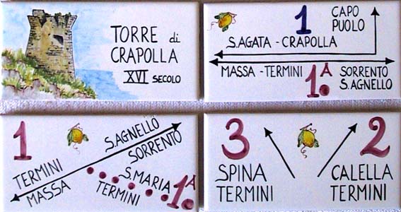
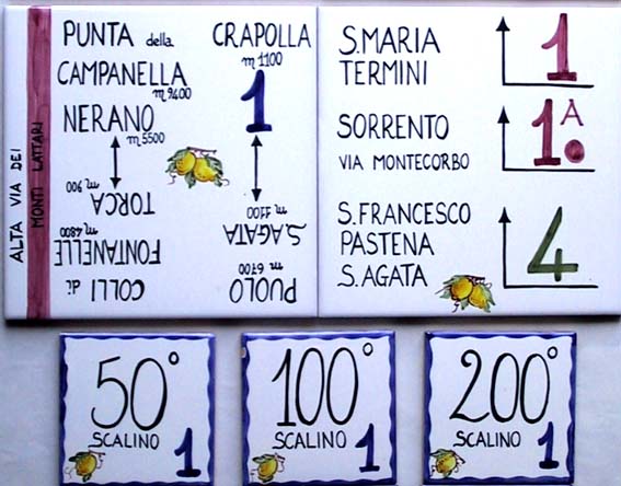
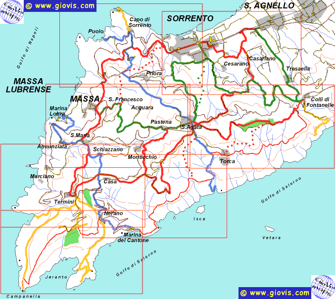
Massa Lubrense (20 sq.km) is virtually triangular in shape - its north-eastern side borders with Sorrento, whilst the other two sides are formed by the Gulf of Salerno and the Bay of Naples, with Punta della Campanella at its vertex, facing the island of Capri, just 5 km away. From the administrative point of view, apart from the main town there are another 17 villages which have developed from the ancient hamlets and are still linked by an intricate network of paths, mule tracks and lanes as well as by the main roads. In 1990, 22 footpaths (covering a total 110 km) were located by Giovanni Visetti set back from the main roads, the noise and the large urban centres. The routes illustrated in this brochure are also marked along the actual pathways with coloured stripes which become more frequent and evident in the proximity of crossing points and turnings, where you can also often find ceramic tiles bearing the same coloured signs and indicating the direction to follow and the distance between the various villages. With this system of signs anyone can go from one place to another without taking the wrong turning or ending up in a dead end and ensures that you are in fact following the right path which is not necessarily the shortest but is without doubt the most interesting and panoramic. | |
| These walks will take you through lemon and olive groves, alone mule tracks and footpaths, through copses of chestnut and oak trees to reach ancient villages, vast uninhabited areas submerged in thick Mediterranean vegetation, lime cliffs dropping steeply down to sea, archaeological remains, Saracen towers and scenic viewpoints. Even the most expert excursionists used to the beauties of the mountain trails with their snowy peaks and verdant valleys cannot fail to be enchanted by these vast panoramas where the sea and the mountains merge offering magnificent views of the Lattari mountains, the Bay of Naples and the Gulf of Salerno with their islands and rocks. The walks have different characteristics: * three Long Walks (about 7 miles each, red trail sign), more or less parallel to the coast and the ridge, all of them starting in the territory of Sant'Agnello and ending in Termini; * the Alta Via dei Monti Lattari (white/red trail sign) is another trail to the south of these three. It was first marked by the Italian Alpine Club in the late 80's, and goes through the Mediterranean bush that covers the steep hillside facing the Gulf of Salerno; * two Coast-to-Coast itineraries (blue trail sign) that link the seaside villages of Puolo and Marina della Lobra (on the shores of the Gulf of Naples) with Crapolla and Marina del Cantone respectively. These two trails, which are transversal to the previous ones, cross and consequently link them to the sea; * four Connecting Walks (green trail sign), between the main villages - Sant'Agnello, Sorrento, Massa and Sant'Agata - that aren't linked by the previous itineraries; * two Alternative Routes (Montecorbo and Circumpiso) that for a couple of miles come off the respective main itineraries and offer the walkers the possibility of adapting the route to their needs or preferences; * two Links that join the 3 itinerary with the Alta Via dei Monti Lattari * six |
Walking along these paths you may admire the picturesque villages and the beauties of the rural environment with its terraced olive groves and their white dry-stone walls (murecine), its lemon and orange groves with their straw-covered trellises (pagliarelle), its buildings in the characteristic tuff stone with their classical archways and outside stairs, whilst in the less developed areas you can observe the vast variety of vegetation growing spontaneously not only in the wild, but also along the stream banks, at the path edges and in the cracks of the walls. Here you can find brooms and spurges, mastic and myrtle, juniper and rosemary, asphodel, ivy, pine trees, holm-oaks and hay-oaks, to name but a few. You can also see plants suited to tropical climates such as the agave, the cactus and the rare dwarf-palm (Chamaerops humilis). Finally worth noting is a plant endemic to the area of the Punta della Campanella and Capri: the Litodora (Lithodora rosmarinifolia), whose splendid blue flowers stand out in winter. | |