 |
|||||||||||
|
|
|||||||||||
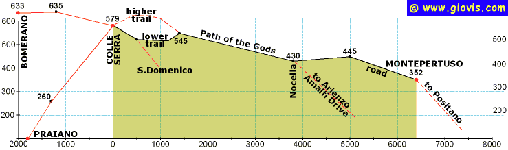
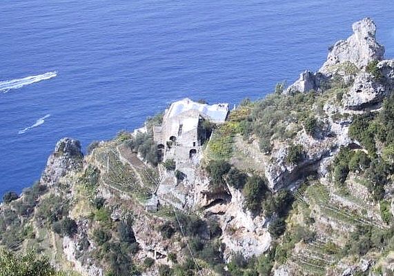
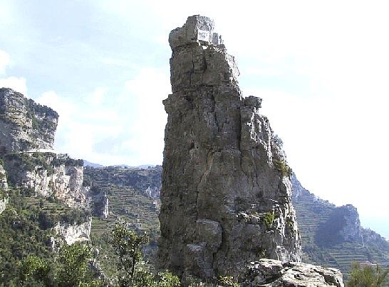
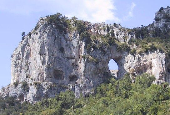
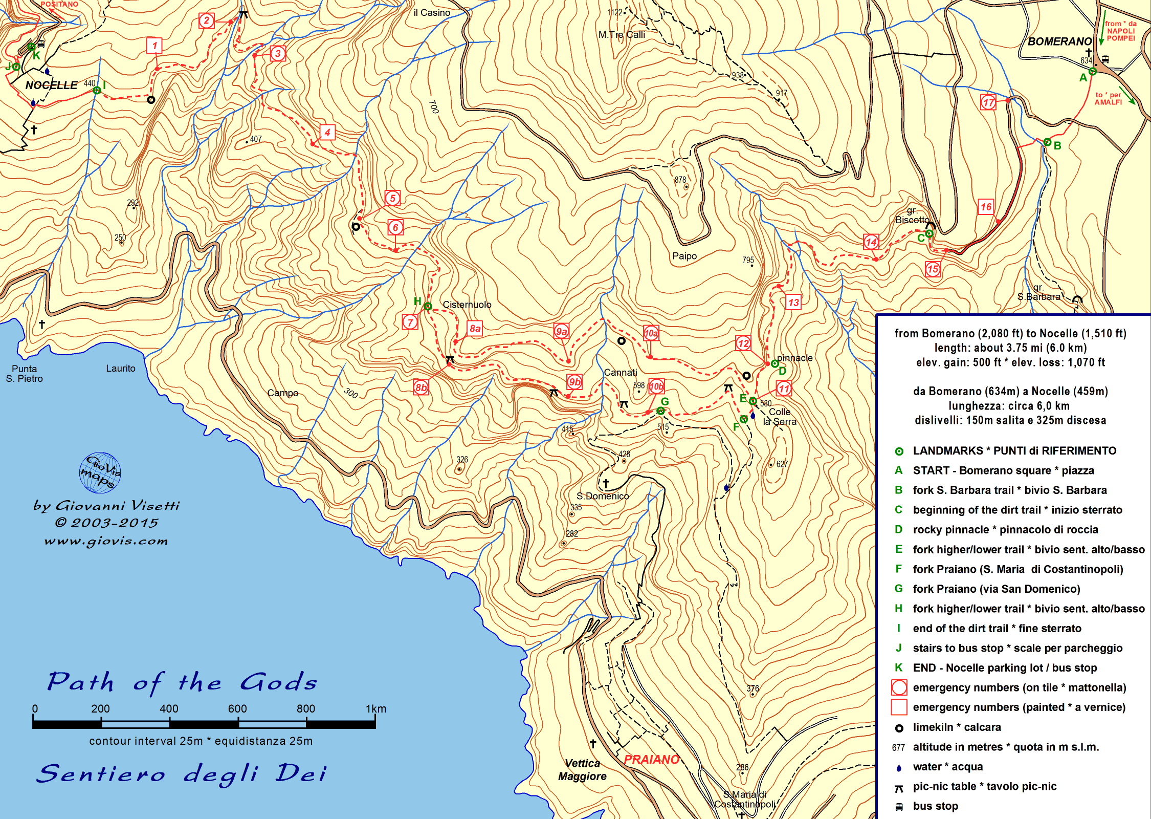
C’è molta confusione sulla definizione del Sentiero degli Dei. Alcuni chiamano così il percorso S. Maria del Castello, Forestale, Capo Muro, Bomerano; altri, presi da scrupolo, aggiungono un “Alto” per poi chiamare il tragitto Bomerano > Nocella: Sentiero degli Dei “Basso”. Personalmente seguo la tradizione, che dice che quello vero va da Bomerano a Nocella, e sono anche del parere che questo percorso, fra quelli in lizza, sia il più titolato ad essere chiamato Sentiero degli Dei, in particolare per il tratto che va da Grotta Biscotto a Nocella, interessante ed eccezionalmente panoramico dall'inizio alla fine. Consiglio di percorrerlo da est verso ovest in modo da avere di fronte la parte estrema della penisola e Capri. Il passo di Colle Serra (580m) è raggiungibile da Praiano o da Bomerano (630m). Da Praiano è anche possibile immettersi sul Sentiero degli Dei circa 500 metri a valle di Colle Serra, passando per il Convento di San Domenico. Se siete saliti da Praiano, vale la pena percorrere qualche centinaio di metri verso Bomerano, al di là di Colle Serra, fino al pinnacolo. Nel primo tratto del percorso Colle Serra > Nocella ci sono due sentieri alternativi più o meno di uguale lunghezza (1,5km): - opzione alta: dalla sella si sale passando al lato di un rudere di calcara e si procede poi più o meno in quota sui 600m per scendere infine ad incontrare l’altro sentiero a quota 545m. - opzione bassa: vi si accede scendendo per pochi metri dalla sella fino ad incontrare la mulattiera che viene da Praiano (c’è una fontana a sinistra), si prosegue a destra fino all’incrocio (520m) col sentiero proveniente da Praiano via Convento di San Domenico e dopo un tratto più o meno in quota si sale nell’ultimo tratto fino ad incontrare il sentiero alto. Da questo incrocio in poi la vegetazione cambia abbastanza radicalmente e si passa dai pochi arbusti ed erba (spesso si incontrano capre e pecore al pascolo) ad una macchia più fitta, ricca di lecci, corbezzoli, erica e rosmarino. Seguendo un percorso molto tortuoso, ricco di saliscendi, si supera l’imponente Vallone Grarelle e si raggiunge l’abitato di Nocella (440m). Di qui si può scendere sulla Statale Amalfitana (oltre 1500 scalini) in località Arienzo o proseguire fino a Montepertuso percorrendo prima un sentiero cementato e poi la rotabile di recente costruzione.
|
|
There is some confusion about the definition Sentiero degli Dei (Path of the Gods): some people use this name for the route Santa Maria del Castello, Forestale, Capo Muro, Bomerano; others, having scruples, add “Alto” (high) and then call the itinerary Bomerano > Nocella: Sentiero degli Dei “Basso” (low). Personally I follow the tradition, saying that the real one goes from Bomerano to Nocella, and I'm also convinced that this is the one most deserving of its name the Path of the Gods; in particular the part between Grotta Biscotto and Nocella, that is extremely interesting and scenic from beginning to end. I suggest walking this trail westward in order to have better views of the Amalfi Coast, all the way to its extremity, with the island of Capri in the background. You can reach the pass of Colle Serra (580m) either from Praiano or from Bomerano (630m). From Praiano you can also choose to meet the Sentiero degli Dei about 500m downhill from Colle Serra, via the Convent of San Domenico.
If you walk up from Praiano, it's
worth walking a couple of hundred metres towards Bomerano, beyond
Colle
Serra, as far as the pinnacolo. - higher option: from the saddle go up past a limekiln and then an abandoned building a little higher than 600m; afterwards go down till you meet the lower trail at an altitude of 545m; - lower option: from the saddle go down to the junction with the muletrack coming from Praiano (there is a fountain on the left), turn right and walk level and then downhill till you reach a fork (520m). The path on the left goes down to Praiano via Convento di San Domenico, the one on the right goes to Nocella. From the point where the two trails meet each other the vegetation totally changes and you leave the grassy terraces (once cultivated) where you can often see goats and sheep grazing and enter an area rich with oaks, chestnuts, strawberry trees and bushes of heather, rosemary and rock roses. Following a winding route, with several ups and downs, you cross the imposing Vallone Grarelle and reach the tiny village of Nocella (440m). From here you can walk down to the Amalfi Drive at Arienzo (over 1500 steps) or continue to Montepertuso walking first along a concrete path and then an asphalt road.
|
|||||||||